Transforming Mobility Barriers to Connectivity: Examining the Impact of the AeroATL Greenway Plan in Reconnecting Communities Around Aerotropolis Atlanta
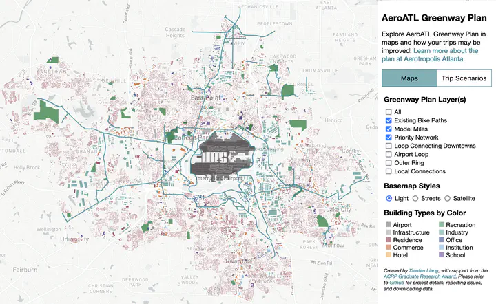 An image of the AeroATL Greenway Plan web tool that shows the study area, parcel-level land uses, and parts of the Greenway Plan (teal lines) used in scenario modeling computation (including existing bike paths, Model Miles, and Priority Network).
Abstract
Airports are critical connectivity infrastructure that supports regional mobility flows and elevates cities’ positions in an interconnected global network. Yet, airports can also be mobility barriers that incentivize car-centric developments, preventing locals from getting to non-airport destinations. Using Hartsfield-Jackson Atlanta International Airport (H-JAIA) and AeroATL Greenway (the Greenway), a newly proposed trail plan in Atlanta Aerotropolis region, as a comparative case study, we quantified H-JAIA’s barrier effect on Aerotropolis residents’ biking and walking trips and evaluated the effect of the Greenway on improving residents’ biking and walking trips distance and experience. Our results show evidence that H-JAIA and its surrounding environment impede local mobility flows. The Greenway has stronger impact at improving trip experience than reducing distance, yet the specific effect varies by segments and implementation scenarios. These results are further validated on the route level with community stakeholders as they interact with a Greenway web tool we developed in a participatory modeling workshop. Insights are consolidated into community trust and commitment to further the Greenway implementation.
This project is developed with Perry Yang and curated through Aerotropolis design studio at Georgia Tech in 2020 and 2021. It is funded by The ACRP (Airport Cooperative Research Program) Graduate Research Award 2022, and supported by Aerotropolis Atlanta.
Keywords: Airport; Aerotropolis; Mobility; Greenway; Participatory Modeling