A review of spatial network insights and methods in the context of planning: Applications, challenges, and opportunities
 A collaborative planning framework with spatial networks
This work is completed with Yuhao Kang, a Geography PhD student at University of Wisconsin as a submission to 2020 CUPUM conference as a book chapter.
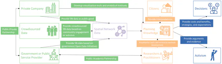
With the rise of geospatial big data, new narratives of cities based on spatial networks and flows have replaced the traditional focus on locations. While plenty of research that have empirically analyzed network structures, there lacks a state-of-theart synthesis of applicable insights and methods of spatial networks in the planning context. In this chapter, we reviewed the theories, concepts, methods, and applications of spatial network analysis in cities and their insights for planners from four areas of concerns: spatial structures, urban infrastructure optimizations, indications of economic wealth, social capital, and residential mobility, and public health control (especially COVID-19). We also outlined four challenges that planners face when taking the planning knowledge from spatial networks to actions: data openness and privacy, linkage to direct policy implications, lack of civic engagement, and the difficulty to visualize and integrate with GIS. Finally, we envisioned how spatial networks can be integrated into a collaborative planning framework.